Carbon Cycle and Calcium Cycle in Karst Dynamic System (KDS)
Carbon Cycle and Calcium Cycle in Karst Dynamic System (KDS)
Calculations of carbon sink in typical rivers
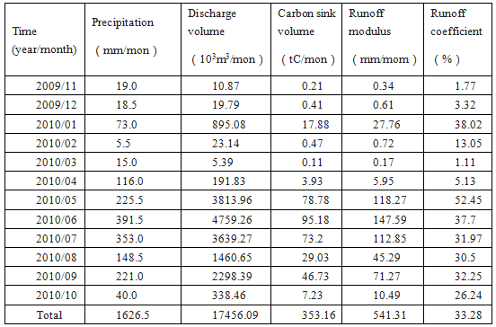
The karst drainage area of Qingmuguan (karst valley area), Chongqing, is located at the junction of Beibei District, Shapingba District and Bishan County. The average precipitation and temperature of this region are 1250 mm and 16.5℃ respectively. Qingmuguan developed in the strata of Jialingjiang Formation, Lower Triassic (T1j) and Leikoupo Formation, Middle Triassic (T2l) and those strata are composed of mixed limestone, dolomite, dolomitic limestone and conglomeratic limestone. The cathment of the underground water of Qingmuguan is 12.9 km2, with a karst area of 11.2 km2. The variety of the HCO3-g/s flux can be shown in the following figure and it is calculated that the carbon sink is 27.87 t/a.km2.
9BJG2VN6")
Geological profile of Qingmuguan
1 – Carbonate rock 2 –Conglomeratic limestone 3 – Erosional fracture and crack 4 – Undergroun driver and its outlet 5 – Sinkhole

The variety of the HCO3- g/s flux of the Qingmuguan underground river
The catchment of the Banzai Underground River in Maolan (Peak-cluster depression – primary forest) is situated in the border zone of Libo County in Guizhou Province and Huanjiang County in Guangxi Province. The average precipitation and temperature of this area is 1752.5 mm and 15.3℃. This underground river developed in the strata of Datang Formation and Baizuo Formation of Lower Carboniferous, Huanglong Group of Middle Carboniferous, Maping Group of Upper Carboniferous and Qixia Fromation and Maokou Formation of Lower Permian and those strata are composed of pure limestone and dolomite. The catchment of this underground river is 32.25 km2 and it is calculated that the carbon sink is 10.95 t/a.km2.
Calculation of carbon sink in the observation weir
Preliminary regional estimation of carbon sink flux by carbonate rock corrosion in the Pearl River Basin
Based on the case study of the Pearl River Basin, IRCK researchers comprehensively analyzed the factors impacting karstification and carbon sink, collected existing monitoring data, and created a regression equation with the dissolution rate, annual precipitation, soil respiration rate and net primary productivity (NPP) of typical observation sites. Taking GIS as a technical platform, the amount of CO2 uptaken from air/soil by karstification in the Pearl River Basin was estimated combining the carbonate categories and their distribution. The results showed that the karst corrosion rat raster chart (g CaCO3 m-2a-1), the annual CO2 consumption due to carbonate rock corrosion is 1.54×10⁷ t CaCO3 a–1, equal to 6.77×10⁶ t C a–1.
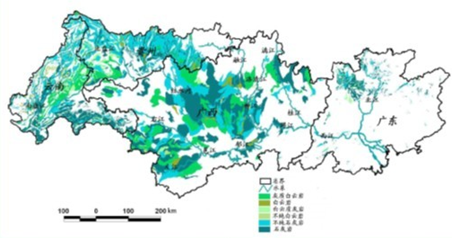
Distribution of different categories of carbonate rocks in the Pearl River Basin
![说明: C:UserssunshouenAppDataRoamingTencentUsers405806487QQWinTempRichOle14A0FHWUAN[[C]]W6L6PQMJ.png](./W020200731577702643053.png "14A0FHWUAN[[C]]W6L6PQMJ")
Corrosion rate distribution in karst area of the Pearl River Basin
Estimation of carbon sink flux by karstification in the Pearl River Basin
![说明: C:UserssunshouenAppDataRoamingTencentUsers405806487QQWinTempRichOleAL`}R@MU{%{D]2G4JH`LF54.png](./W020200731577702689563.png "AL`}R@MU{%{D]2G4JH`LF54")
 桂公网安备 45030502000336号